Monday 5th July 2010
Caught the bus from Whitstable to Herne Bay. From the pier (GR173682)set off along the promenade past some quite attractive gardens and alongside the harbour. The wind farm is apparently the Kentish Flats Wind Farm and is about 8 to 10 miles out to sea. Walked through an attractive bandstand area.

The weather is good but not as hot as previous days, a bit cloudy a bit sunny and not as humid as it has been. The clock tower[1] carries a memorial for the South African War with a list of those that volunteered including a certain E.C.Moore of the Sharpshooters[2]. Pass a parade of Georgian town houses to reach The Ship. Pass King’s Hall Theatre which has fine cast iron columns and railings. This marks the end of the town really. Pass Herne Bay Sailing Club and the National Coastwatch Institution building (apparently this is not part of the Coastguard and is under threat as the building has been sold by the council).
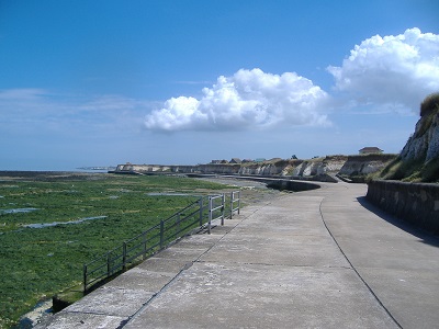
Walking on a long fairly straight concrete promenade on top of the sea wall with a shingle beach on the left with breakwaters and on the right low cliffs and rough land. Up ahead are some more prominent cliffs with the ruined St Mary’s church towers of Reculver visible at the end of them. At Bishopstone the wide concrete promenade ends and the Saxon Shore Way goes off to the right up a path (GR205687) but decided to carry on straight ahead as it is low tide and Reculver can be reached along the beach.

Cross a wooden bridge where some steel steps go up over the cliffs but continued along the beach. Go round the headland on the beach which would be impossible at high tide so this is why the Saxon Shore Way goes over the top. Round the headland the church can be seen on the next headland. The cliffs are the soft clay which are familiar all down the east coast and they are indeed eroding away with evidence of fresh falls. A bit of sand here which is good to walk on again although will probably get fed up with it as it usually gets to be hard work.

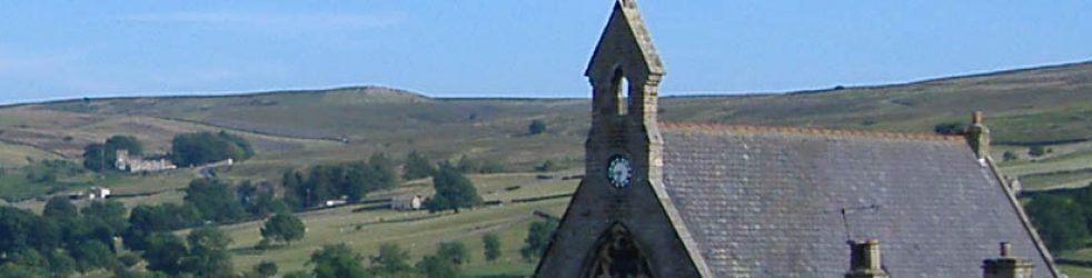
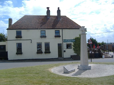
Reach an area of rock pools just before Reculver very crowded with several school parties. Use a stony track to climb up of the beach to reach Reculver (GR227693), the church and caravan park. There is also a pub here called the King Ethelbert Inn. The cross in front of the pub was commissioned by the Canterbury City Council and the Dean and Chapter of Canterbury Cathedral to celebrate the Millennium. The Saxon Shore Way goes inland here but my route continues along the coast. Had a couple of pints in the King Ethelbert and then walked up to the twin towers of St Mary’s Church. Can see a long way ahead from the top of the hill where the towers are, probably as far as Margate where there is a tall building in the distance.
Turn left at a signpost to the Roman Fort Wall East Gate and then continue along the sea wall. This is the Northern Sea Wall which is long and straight and the land to the right is marsh and flat and to the left is the sea and shingle beaches. To the right are series of man-made channels which are the shell fish hatchery[3]. Reached the junction with the Wantsum Walk (GR252692) where the signpost says that this is the Viking Coastal Trail with Minnis Bay ahead. Reach the next junction with the Wantsum Walk (GR273694) at Plum Pudding Island. This is a long sea wall top walk from Reculver to Birchington. There is the alternative of a grassy track behind the sea wall that might be better in some circumstances.
Birchington is now very visible andseems to consist of half a dozen blocks of flats and some white chalk cliffs. The beach is now sandy with rocks about 100 yards out. On the way into Birchington the beach gets a bit bigger there are beach huts, a promenade and up on top of the low cliffs is the continuation of the sea wall path which is an asphalt path but there is also a grassy stretch to walk on. This is Minnis Bay and the pub here is called The Minnis. Just beyond the pub reached the road that leads into Birchington which again has conveniently wide areas of grass to walk on. Reach the flats (GR288698) and use some steps to go down to the lower promenade and go under the low white cliffs.
Some brickwork here that look like fortifications and it looks like caves or entrances into the cliffs have also been bricked up. Reculver is still visible back in the distance with the twin towers quite prominent but just here the beaches have ended and it is rocky for a few hundred yards out to sea. The cliffs go on for some way but soon get a view of Margate on the horizon. This is actually quite a strange area, very, very quiet with the sea some way away across the rocks, the cliffs a big wide-open promenade, no people about and the town really just yards away on top of the cliffs.
Rounding a headland the cliffs can be seen for some way into the distance perhaps as far as Margate. After Berisford Gap get more brickwork and impressive steps through the brickwork and up through the cliffs. Reach a derelict house built into the cliffs and various other strange tunnels and entrances. Some of these are private entrances to houses on top of the cliffs which are about 30 feet high here. The sea wall path stops at a small sandy bay, Epple Bay, although the cliffs continue so have to get off the sea wall (GR308698) and up onto the cliffs.

Climb the steps at the end of the bay. Reach the road and turn left. Pass by some large new houses on the right and a promenade can be seen under the cliff but it is not clear how it is reached. On reaching the larger Westgate Bay go down some concrete steps to the promenade where there is a no-through sign that indicates that promenade does not connect back to Epple Bay. This is quite a pleasant sandy bay with some beach huts on the far side and small number of buildings of Westgate itself. Stopped for a bacon sandwich at the West Bay Cafe.

Continue on the promenade past the beach huts and underneath the chalk cliffs again. Can see quite a few ships out at see – guess these are ferries for Ramsgate, Dover and Folkestone. Round the cliffs and St Mildred’s Bay, another sandy bay, comes into view and beyond it Margate itself. Again a block of flats on the horizon so Kent County Council must have built blocks of council flats in each of the towns along the coast. Many cafes, fish and chip shops and so on at St Mildred’s Bay. At the end of the bay is another of the Royal Bank of Scotland sponsored Millennium National Cycling Network signs.

Looks to be a choice here so instead of continuing along the promenade underneath the cliffs am going to take a clifftop path. The path leads back onto the road but there is grass to walk on. Quite pleasant gardens up here and a view of Margate with Westbrook Bay in front of it. Walking along Royal Esplanade and at the end of it turn right up Westbrook Gardens. Turn left at the main road and pass the impressive building of the Royal Sea Bathing Hospital founded 1791 with the current building dating from 1859. Turn right down Station Road to reach the grand fifties building of Margate station.

End of the walk. Quite a good day really, Herne Bay to Reculver was fine and Reculver was an interesting place. Reculver to Birchington was quite boring but then the chalk cliffs and bays to Margate were very attractive.
[1]On 11th October 1837, Mrs Ann Thwaytes, a wealthy lady from London, donated around £4,000 to build a 75 feet (23 m) clock tower on the town’s seafront. It is believed to be the first freestanding purpose built clock tower in the world.
[2] E.C.Moore does not appear in the nominal roll for the 21st Imperial Yeomanry (Sharpshooters) so was probably a member of the first contingent of the Sharpshooters to go to South Africa. My interest in this lies in the fact that my grandfather David Robert Corryn Morrice served in the Sharpshooters in the Boer War and I have transcribed and published the diary of his commanding officer Lieutenant-Colonel Alexander Weston Jarvis. (A Boer War Sharpshooter, K.Case and W.Osborne, Salient Press, 2010).
[3] Some of Barnes Wallace’s Dambuster bouncing bombs have been found here as the area was used for training.
Days from Chepstow 101
Miles today 11.9
Miles from Chepstow 1344.2
