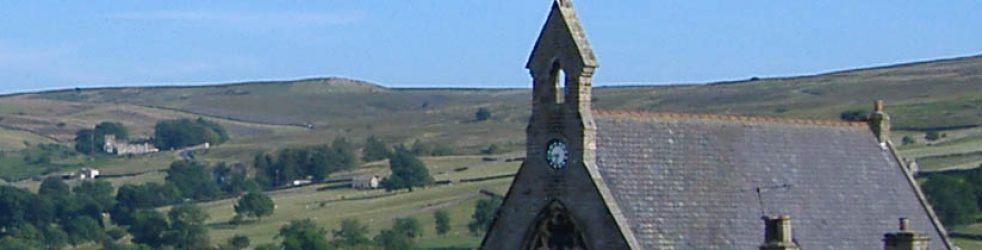
Monday 9th April 2018
Took a taxi from Penzance to the Logan Rock Inn (GR394230) at Treen and continued through the village to take a path straight ahead. Took the sign post to Sugar Lane and turned right at the lane. Beautiful morning again, blue sky, sunny, but unfortunately rain predicted later in the day so it is just as well that I got started early (the rain never arrived).

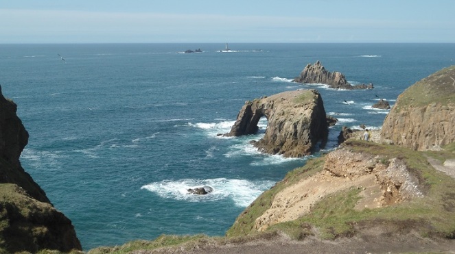
Passed the entrance to a campsite (GR392228) and the road turned left and became a track leading down to the sea. Reached the coast path at Treen Cliff (GR339225) and turned right. Could see Porthcurno and what was presumably the Minack Theatre although I could not quite make it out from here. The path was muddy between hedges but soon took a path off to the left, signposted National Trust Porthcurno, down towards the cliffs.

The steep decent to the sandy cove at Porthcurno was a bit of a rock scramble in places.

Walked out on the path alongside the cove to reach the foot of the Minack Theatre steps (GR387221) which are indeed very steep stone steps going up the cliff.

At the top crossed the car park to continue on the coast path. Climbed up on a decent path towards Carracks or Pedn-mên-an-mare and then dropped down stone steps to Porth Chapel (GR381219).

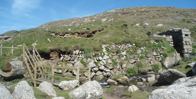
At Porth Chapel the path was diverted right up the hill at the spot where there is a memorial stone to RSPCA inspector Mike Reid who died on 7th February 2016 near here trying to rescue seabirds. Climbed the steps up to a wooden bridge across a stream and then on to St Levan’s Well to continue on more steps.

The path continued fairly level for some way and then began to wind its way between bushes into Porthgwarra (GR371217). The café was open which was lovely so had a cup of tea sitting outside in the sunshine. Afterwards took the lane up behind the café up to some houses and then through a wooden gate. Turned right to take a clear track to cross what looked like moorland but was actually very low-growing gorse bush. This diversion was avoiding a part of the coastal path to save energy and was actually a bit like walking in Swaledale (where we have a cottage). Continued across the sort of moorland to reach the official path at Ardensawah Cliff (GR361227).

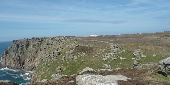
Dropped down to cross a stream by stepping stones at Carn Trevean (GR361229) and climbed up the other side to reach a good fairly level path that carried on level for the next mile or so across Higher Bosistow Cliff.
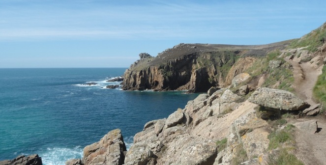
The Longships lighthouse out on the rocks at Land’s End had been in view for quite some time and now the buildings at Land’s End also came into view. Steep steps descended to cross a small stream by stepping stones just beneath the isolated house at Nanjizal (GR358235) and then another stream by a wooden footbridge. Very impressive along here with the path clinging to the not very high but rocky Lower Bosistow Cliff heading towards Zawn Reeth (notable as our cottage in Swaledale is at Reeth).
There were lots of alternative paths approaching Land’s End so took the most direct one. Also lots of people walking, not many of them properly equipped, but all of them performing better than me, leaping over boulders and so on.
Rather strangely there is a kind of zoo as you approach Land’s End with llamas, donkeys etc. (GR345246).

Went into the hotel bar and had a couple of pints of Tribute and a brie and bacon ciabatta which was OK although it took some time to arrive.

I don’t know what I feel about reaching Land’s End really because it is a big, big landmark but it is also a bit of an anti-climax and I was not really sure where Land’s End actually was. Took a photograph of the traditional signpost but actually have to pay to have it done with your own place name put on it. As it is a beautiful day during the Easter school holidays the whole Land’s End complex is very busy. As many others have previously commented there is a feeling of intrusion by all these people on such a sacred spot to walkers, but then again they were clearly enjoying themselves so why not.
Walked on to the First and Last Café, perhaps that is the real Land’s End – don’t know (As far as I can work out from the OS map this is the westernmost building with nearby Dr Syntax’s Head the westernmost bit of mainland Britain (GR341254)). At least I felt initially refreshed as I continued on a stone laid path away from Land’s End towards Sennen. I have made the turn and am now heading for home, but did not have the planned Southern Comfort celebration. I have completed the four cardinal points of the walk around England – a cow field in Rosgill North Yorkshire, the easternmost monument hidden away behind an industrial area in Lowestoft, the strange but evocative southern tip of England at The Lizard and now the aptly named Land’s End.

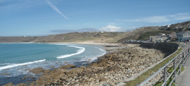
Crossed Mayon Cliff to reach the road on the outskirts of Sennen (GR350262) where the beach was certainly crowded for early April.

Followed the road downwards towards the beach, but should have taken heed of a coast path sign earlier on and gone in front of the lookout station from where the path runs down to the beach. As it was steps wound down between houses to reach the harbour area. Turned right through the car park to reach the sea wall along the front.
At this point I made a major mistake and decided to take the road to St Just which despite my week’s of planning I somehow had down as a little over a mile but which in fact was about 4 miles. Left Sennen by climbing the steep hill on the road to reach a big car park at the top of the hill (GR359263). Turned left on a footpath across the grass towards the main road, and reached the road at Sennen School and turned left (GR363261). Walked along the main road to its junction with the B3306 road to St Just where I took one of my many rests. Fortunately a couple who I had first seen at the Minack Theatre and who I passed or was passed by all day saw me and most kindly stopped to give me lift into St Just. By one of those over-common coincidences they had originally net whilst working at Plesseys in Beeston, Nottingham, about half a mile from my home. I accepted the lift in full accordance with my rules for the walk.
I was dropped off at St Just bus station from where I took the bus to the end of its route at Pendeen (interesting for mines etc which were to be the centrepiece of the next day’s walk) and then back through St Just to Penzance.
Days from Chepstow 166
Miles today 12.6
Miles from Chepstow 2041.8

Lovely photos. I must say I didn’t like Land’s End very much. As you say, there is no focal point to it, and I don’t know why it has become so iconic. The Lizard is a much nicer place, in my opinion.
LikeLike
Thanks for the compliment but I think my photos don’t compare with your excellent ones. I’m continuing to enjoy your Scottish exploits although I don’t expect to be following in your footsteps,
Keith
LikeLike